

Albuquerque Crash Hotspots: What the Latest Data Reveals

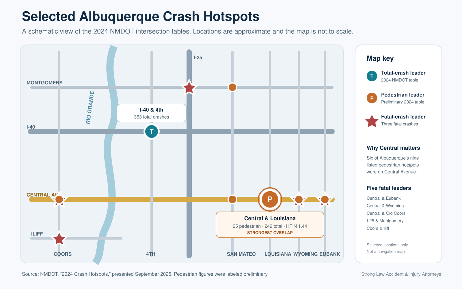
I-40 and 4th had the most reported crashes in NMDOT’s 2024 hotspot table, with 363. Central Avenue and Louisiana Boulevard is the clearest overall hotspot because it also led the pedestrian list with 25 crashes and appears in MRCOG’s traffic-adjusted High Fatal and Injury Network. Five Albuquerque locations tied for the most fatal crashes, with three each.
There is no single “most dangerous” intersection because each measure answers a different question. Raw totals show where crashes were concentrated. Pedestrian and fatal-crash counts show where the outcomes were more severe. MRCOG’s score compares fatal and injury crashes with traffic volume.
These figures show patterns across many crashes. They cannot prove why one collision happened or who was at fault.
These figures show patterns across many crashes. They cannot prove why one collision happened or who was at fault.
About the data: The finalized 2024 Albuquerque Community Report was released in November 2025. The intersection tables come from a September 2025 NMDOT presentation, which labeled its 2024 pedestrian figures preliminary. MRCOG’s current High Fatal and Injury Network uses a separate five-year dataset covering 2019 through 2023.
What Does “Most Dangerous” Actually Mean?
Many online lists treat every crash ranking as if it answers the same question. It does not.
| Measure | What it tells us | Key limit |
|---|---|---|
| Total crashes | Where the most crashes were reported | Busy roads often rise to the top because more vehicles use them |
| Fatal crashes | Where at least one crash caused a death | Locations with the same count may have very different traffic levels |
| Pedestrian crashes | Where people walking were struck most often | The count does not adjust for vehicle or foot traffic |
| HFIN intersection score | Where fatal and injury crashes were high for the amount of traffic | It is a planning score, not proof of fault |
A busy interchange can lead the raw count because thousands of vehicles use it each day. A city intersection may have fewer total crashes but a worse pattern for people walking. Total volume, severity, and traffic-adjusted injury risk are not the same measure.
How Many Crashes Occurred in Albuquerque in 2024?
The finalized 2024 Albuquerque Community Report, prepared by the University of New Mexico for NMDOT, counted:
- 15,529 total reported crashes
- 95 fatal crashes
- 4,447 injury crashes
- 10,987 property-damage-only crashes
- 99 people killed
- 255 people with suspected serious injuries
The report also recorded 309 pedestrian crashes and 168 bicycle crashes in Albuquerque during 2024.
These totals cover reported crashes on public roads involving at least one motor vehicle that caused a death, an injury, or at least $500 in property damage. Private-property crashes, including many parking-lot incidents, are not included.
Which Albuquerque Locations Had the Most Total Crashes?
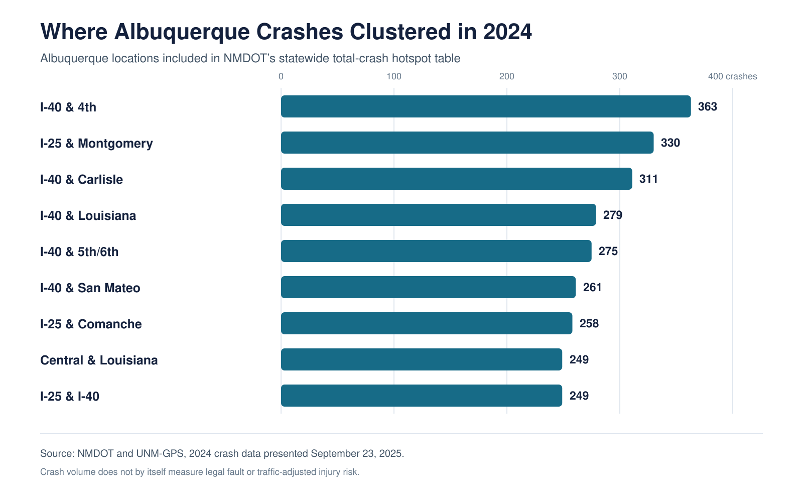
NMDOT’s September 2025 Crash Hotspots presentation included nine Albuquerque locations in its statewide 2024 total-crash table. A tie at 249 crashes expanded the published list.
| Albuquerque location reported by NMDOT | Total crashes in 2024 |
|---|---|
| I-40 and 4th | 363 |
| I-25 and Montgomery | 330 |
| I-40 and Carlisle | 311 |
| I-40 and Louisiana | 279 |
| I-40 and 5th/6th | 275 |
| I-40 and San Mateo | 261 |
| I-25 and Comanche | 258 |
| Central and Louisiana | 249 |
| I-25 and I-40 | 249 |
Interstate junctions and nearby frontage-road areas dominate the list. That does not make them the highest-risk locations for each driver. It shows where reported collisions were most concentrated by count.
Where Did Fatal Crashes Cluster?
The same NMDOT presentation identified five Albuquerque locations with three fatal crashes each in 2024:
- Coors Boulevard and Iliff Road
- Central Avenue and Eubank Boulevard
- Central Avenue and Wyoming Boulevard
- I-25 and Montgomery Boulevard
- Central Avenue and Old Coors Drive
Three of the five are on Central Avenue. I-25 and Montgomery is the only location that also appears near the top of the 2024 total-crash table.
A fatal-crash count is not the same as a fatality count. A “fatal crash” means at least one person died. One crash can cause more than one death.
Where Were the Most Pedestrian Crashes?
NMDOT’s 2024 pedestrian table included nine Albuquerque locations among the statewide leaders:
| Albuquerque pedestrian hotspot | Pedestrian crashes in 2024 |
|---|---|
| Central and Louisiana | 25 |
| Central and San Pedro | 17 |
| Central and Eubank | 16 |
| Central and Wyoming | 16 |
| Coors and Central | 14 |
| San Mateo and Montgomery | 12 |
| Central near 3rd Street | 10 |
| I-40 and 4th | 10 |
| I-40 and 2nd | 8 |
Six of those nine locations are on Central Avenue. This is a very different picture from the total-crash list, which is led by interstate junctions.
The concentration along Central matters because a person walking has little protection from impact. Signal timing, crossing distance, lighting, speed, turn movements, bus stops, driveways, and blocked sight lines may all matter after a collision.
People hurt while walking can find claim-specific guidance on Strong Law’s Albuquerque pedestrian accident lawyer page.
How Is MRCOG’s High Fatal and Injury Network Different?
The Mid-Region Council of Governments High Fatal and Injury Network, or HFIN, does more than count crashes. Its intersection score compares fatal and injury crashes with the average amount of traffic approaching the location.
MRCOG’s current map covers 2019 through 2023. It reports that 64% of the region’s deaths and injuries occurred on only 7% of its major-road network. MRCOG also warns that the map is a planning tool. Each location still needs a detailed study before anyone can decide what caused the pattern or which safety change may help.
A July 27, 2026 review of the current interactive HFIN map found these higher-scoring named intersections in the Albuquerque area:
| Location in the HFIN map | Fatal crashes, 2019–2023 | Injury crashes, 2019–2023 | HFIN score |
|---|---|---|---|
| I-40 North Frontage Road and Pan American East | 0 | 42 | 2.21 |
| Paseo del Norte and Coors | 0 | 95 | 1.67 |
| Paseo del Norte ramps and 2nd Street | 1 | 80 | 1.63 |
| Central and Louisiana | 1 | 98 | 1.44 |
How we checked the HFIN map: We opened MRCOG’s public 2019–2023 intersection layer on July 27, 2026 and recorded the displayed fatal crashes, injury crashes, and HFIN score for named Albuquerque-area locations. The table shows selected higher-scoring examples, not a complete ranking. Interstate mainlines are excluded, but frontage roads and major local streets can appear. Because the map is interactive, its displayed information may change as MRCOG updates the layer.
These are not raw-crash rankings. A smaller intersection can score highly when its serious-crash history is high for the amount of traffic entering it.
Which Intersection Stands Out Across All Three Measures?
Central Avenue and Louisiana Boulevard is the strongest cross-dataset signal:
- 249 total crashes in NMDOT’s 2024 table
- 25 pedestrian crashes, the highest number in the statewide 2024 pedestrian table
- One fatal crash and 98 injury crashes in MRCOG’s 2019–2023 HFIN map
- An HFIN score of 1.44, well above MRCOG’s stated regional intersection average of 0.37
This does not mean every approach, turn, or time of day is equally risky. It does show why Central and Louisiana deserves attention beyond an old intersection list.
What Patterns Stand Out?
- I-40 and I-25 dominate the raw count. Heavy traffic, ramps, lane changes, congestion, and frontage roads create many chances for vehicles to cross paths.
- Central carries a separate pedestrian and fatal-crash burden. Bus stops, wide crossings, turns, driveways, and hit-and-run evidence can matter, but the facts still outweigh the road’s reputation.
- Coors, Paseo del Norte, and Rio Bravo stand out in injury data. The HFIN can reveal serious patterns that a count of all crashes may hide.
Can Hotspot Data Prove Fault After a Crash?
No. Crash data can show a repeated pattern and help public agencies decide where to study or improve a road. It can also help an investigator understand which evidence may matter at a complex intersection.
Hotspot data does not prove that:
- One driver ran a red light
- A pedestrian crossed against a signal
- Speed caused the collision
- A road was legally defective
- A city or state agency knew about a dangerous condition
- The other driver was entirely at fault
Fault in an Albuquerque crash must be shown with evidence from that event. New Mexico follows pure comparative fault. An insurer may blame more than one person, but someone who shares fault may still recover a reduced amount.
Strong Law’s Albuquerque car accident lawyer page explains how crash reports, insurance, injuries, and disputed fault may affect a claim.
What Evidence Should Be Preserved After an Intersection Crash?
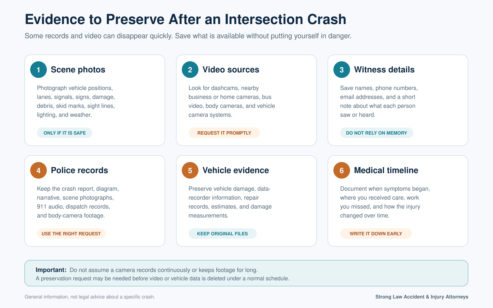
Busy intersections can produce more evidence than a crash report alone, but some of it may disappear quickly.
Useful evidence includes:
- Photos of vehicle positions, lanes, signals, sight lines, debris, skid marks, lighting, and weather
- Dashcam, motorcycle-camera, bicycle-camera, business, home, bus, or vehicle video
- Witness names and contact information
- The APD crash report, diagram, and written narrative
- 911 audio, dispatch records, body-camera footage, and scene photographs when available
- Vehicle data-recorder information, damage measurements, and repair records
- Medical records showing when symptoms began and how the injury changed over time
The Albuquerque Police Department sells traffic crash reports online for $7.50. Reports can also be obtained in person at the Law Enforcement Center. Other city materials may require an ABQ Records request.
Do not assume every camera records at all times or keeps footage for long. Identify possible video sources quickly. A preservation request may be needed before a file is deleted under a normal schedule.
Motorcycle, bicycle, and pedestrian cases often require different evidence. Strong Law provides separate guidance for Albuquerque motorcycle crashes and Albuquerque bicycle accidents.
What if Road Design or a Public Agency Contributed?
A high HFIN score does not, by itself, establish a legal claim against the City of Albuquerque, Bernalillo County, or NMDOT.
A road-related investigation may look at signals, sight distance, work zones, pavement, lighting, signs, maintenance, earlier complaints, studies, and which agency controlled the road. Government claims can follow different notice and filing rules.
If a serious injury may involve a signal problem, road construction, a missing sign, unsafe pavement, or a public vehicle, the evidence should be reviewed promptly. The Albuquerque personal injury lawyer page explains how cases involving public agencies and several responsible parties may differ.
What Is Albuquerque Doing About High-Injury Roads?
Albuquerque’s Vision Zero program uses crash data to work toward ending traffic deaths and serious injuries by 2040. The City says it also considers crash history, speed, schools, community input, and neighborhood vulnerability when choosing automated speed-enforcement locations.
Road projects and safety programs can change conditions. These rankings may also change as NMDOT and MRCOG release newer crash data.
Frequently Asked Questions
What is the most dangerous intersection in Albuquerque?
I-40 and 4th led NMDOT’s 2024 total-crash table. Central and Louisiana led the pedestrian table and also stands out in MRCOG’s traffic-adjusted injury network. Five locations tied at three fatal crashes each.
Which Albuquerque road appears most often in the pedestrian data?
Central Avenue appears at six of the nine Albuquerque locations in NMDOT’s statewide 2024 pedestrian-hotspot table. Central and Louisiana had the highest count, with 25 pedestrian crashes.
Does a crash hotspot prove the other driver was at fault?
No. A hotspot describes a pattern across many crashes. Fault in one collision depends on evidence such as traffic signals, right-of-way, speed, visibility, video, witness accounts, vehicle damage, and the police investigation.
Does MRCOG’s HFIN include I-25 and I-40?
Interstate mainlines are excluded. Major city roads and frontage-road intersections may still appear.
How do I get an Albuquerque police crash report?
APD directs online requests through Carfax for Police and currently lists a price of $7.50. Reports can also be requested in person on weekdays at the Law Enforcement Center at 400 Roma NW. Check APD’s official page for current hours and fees.
How current is this Albuquerque crash-hotspot data?
This article uses finalized 2024 Albuquerque crash totals, NMDOT’s 2024 intersection tables, and MRCOG’s 2019–2023 High Fatal and Injury Network. The findings should be reviewed when those agencies publish newer reports.
Injured in a Serious Albuquerque Crash?
Hotspot data can explain the setting, but it cannot show what happened in one collision. A serious crash may require a review of the scene, signals, video, witnesses, vehicle damage, medical records, and insurance coverage.
Strong Law Accident & Injury Attorneys offers free case reviews for people injured in Albuquerque and throughout New Mexico. Qualifying cases are handled on a contingency fee basis, with no upfront attorney fees or hourly bills. Call (505) 465-8341 or contact Strong Law to discuss the next steps.

See If Your Injury Claim May Qualify
Answer a few quick questions to help Strong Law understand what happened and whether your claim may qualify for a free review.
